A bone of contention between India-China
Why is Aksai Chin in the news?
China has released its official ' standard map' for 2023, which includes Arunachal Pradesh and the Aksai Chin area. The map issued depicts Arunachal Pradesh, which China claims as South Tibet, and Aksai Chin, which it conquered as part of its territory during the 1962 conflict. The image also includes China's claims over the nine-dash line, claiming a substantial portion of the South China Sea.
Aksai Chin's Geography
- Location
- Aksai Chin is situated in Eastern Kashmir, midway between China and India. - Terrain
- Known as the Soda Plain, Aksai Chin is a high-altitude salt land marked by a stark and arid landscape with scant rainfall.
- This region is devoid of permanent human habitation. - Part of the Tibetan Plateau
- Aksai Chin forms a southwestern extension of the Tibetan Plateau, making it an integral component of this high-altitude plateau. - Elevation and Topography
- With an average elevation soaring to 17,000 feet (5,180 meters), Aksai Chin primarily comprises a rugged high plain.
- Encircled by natural fortifications, it is hemmed in by the imposing Kunlun Mountains to the north and northeast and the formidable Karakoram Range to the west and southwest.
- The northwestern sector presents a more mountainous terrain, while in the east, internal drainage leads to the formation of small alkaline lakes. - Climate and Water Sources
- Aksai Chin experiences a chilly and arid climate, with limited precipitation primarily concentrated in the summer months of July and August.
- The region's vital water sources include the Karakash River and a network of brackish lakes.
Border Sharing and Origin of the Dispute
Border Sharing
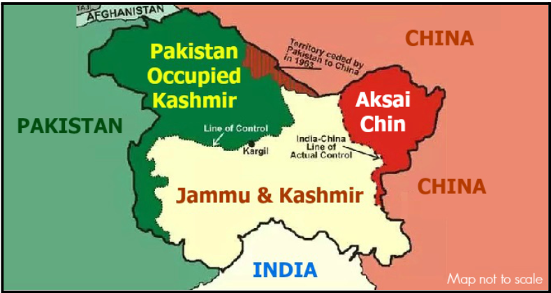
- Aksai Chin's territory is strategically located at the confluence of three nations: the People's Republic of China, Pakistan, and India.
- It remains a fiercely contested border region between Bhutan and India.
- Despite India's vocal protests, China retains administrative control over Aksai Chin.
- Geographically, it lies approximately halfway between the Chang Tang Plateau and the Tibetan Plateau.
China’s Claim
China claimed that it was part of the ancient and medieval Chinese empire, which is a convenient claim from an era when boundaries did not have the same sanctity as they did in the times of nation-states. The Chinese government did not object to Ladakh or Aksai Chin being part of India until 1950, when the Indian Constitution adopted the whole of Jammu and Kashmir as its integral territory.
How did the dispute start?
- Aksai Chin stands as a critical and enduring border dispute between India and China.
- Historically, due to its remote and isolated nature, Aksai Chin remained largely overlooked within the Indian subcontinent.
- Once part of the Himalayan Province of Ladakh, Aksai Chin's status changed when Kashmir invaded Ladakh in the 19th century, leading to its incorporation into Kashmir and, subsequently, British India.
- The primary catalyst for the Sino-Indian conflict in 1962 was the discovery of a Chinese-built highway that traversed territory recognized by India as its own.
- This highway, known as National Highway 219, connects Tibet and Xinjiang through Xinjiang, providing China with a strategically advantageous position.
- During the 1950s, China further exacerbated tensions by constructing a military route over Aksai Chin, linking Tibet and Xinjiang.
- The revelation of this route and India's resistance to China's presence in the region were key factors contributing to significant border clashes in 1962.
- Following the conflict, China retained control over approximately 14,700 square miles (38,000 square km) of Aksai Chin, intensifying the ongoing dispute between the two countries.
Pakistan Role
The region’s current contentious status may be traced back to the Indian-Pakistani Kashmir War.
Aksai Chin is part of Pakistan's claim to Kashmir.
The Trans-Karakoram Tract was relinquished by the PRC and Pakistan in a boundary deal in 1963; border accords inked in 1987 imply that Pakistan may recognize claims to the area. So far as we are aware, no Pakistani administration has made an official claim to this territory, and all administrations have given tacit approval to the PRC's claim.
How China Took Control of Aksai Chin?
- Strategic Planning and Road Construction:
- China's ambitions beyond the western boundary of Tibet led to a strategic plan to establish control over Aksai Chin.
- This plan involved the construction of a network of three roads, all under military supervision, to pass through Aksai Chin. - Commencement of Construction
- Actual construction activities on these roads commenced post-1953, a period characterized by the slogan "Hindi-Chini Bhai-Bhai" symbolizing India-China friendship. - Deterioration of Relations:
- By 1959, the camaraderie between India and China had eroded.
- Prime Minister Pandit Jawaharlal Nehru began diplomatically asserting India's sovereign rights over Aksai Chin, which China had effectively occupied. - Strengthening China's Position:
- The situation escalated, leading to the Sino-Indian conflict in 1962.
- After the war, China took measures to fortify its position.
- It unilaterally established the Line of Actual Control (LAC) in Ladakh, which included the Galwan Valley area. - Eastern and Western Sectors:
- In contrast to the eastern sector, where Chinese forces descended as far as Tezpur in Assam during the 1962 conflict, Indian soldiers managed to halt their advance near the current LAC in Ladakh. - Post-War Status Quo:
- Following the conflict, a ceasefire was declared.
- China withdrew to the McMohan Line in Arunachal Pradesh but retained military control over Aksai Chin. - Strategic Significance:
- Chinese leadership in the 1960s saw the occupation of Aksai Chin as a strategic move envisioned by Chairman Mao Zedong.
- They considered it a metaphorical "Damocles sword" hanging over India's head, providing China with the capability to threaten key Indian cities, including New Delhi and Mumbai, as well as India's economic centers.
Strategic Relevance of Tibet
- Despite the fact that it is essentially empty of resources, this region has a strategic role for China since it connects Tibet and Xinjiang.
- The extremely flammable area of Aksai Chin ignited the brief and brutal Indo-China war in 1962. All industries' relationships were completely thawed in the years following the war.
- China poses an immediate threat to Indian sovereignty because Aksai Chin is situated at a high elevation close to Delhi.
- During any confrontation between China and India, China's army may push deep into India's heartland in only two hours. Aksai Chin is a self-contained Chinese satellite that observes Indian operations as well as those in Central Asia.
- Aksai Chin, a cold desert flatland near Bhutan, is primarily occupied by China, which captured the region during the 1950s and consolidated its military grip during the 1962 India-China War.
Conclusion
The Aksai Chin area is administered by China, which includes Hotan County in Xinjiang's Hotan Prefecture and Rutog County in Tibet's Ngari Prefecture. India defines it as being a part of the Leh District of the Ladakh Union Territory. It is located in eastern Kashmir and has been a point of dispute between China and India since the late 1950s.