The Lifeline of South Asia: Exploring the Importance and Magnificence of the Indus River System
Introduction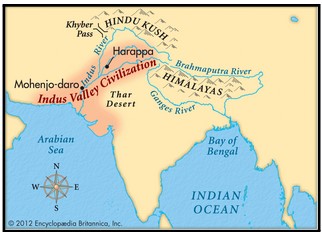
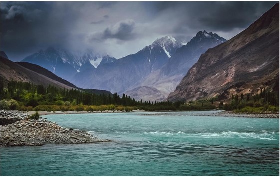
The Indus River system, an ancient and colossal river network, holds paramount importance for South Asia, known as Sindhu in Sanskrit and Mehran in Sindhi, is an extraordinary trans-Himalayan river situated in South Asia. It spans an impressive length of approximately 2,000 miles (3,200 km), making it one of the world's longest rivers. With a vast drainage area of about 450,000 square miles (1,165,000 square km), including the majestic Himalayas, Hindu Kush, and Karakoram Range, it holds immense significance. While 175,000 square miles (453,000 square km) lie within these mountain ranges, the remainder flows through the semi-arid plains of Pakistan. The Indus River showcases a remarkable annual flow of around 58 cubic miles (243 cubic km), which is twice that of the Nile River and three times that of the combined Tigris and Euphrates rivers.
Historical Significance of Indus Basin
The Indus River and its tributaries have played a significant role in shaping the history and civilization of the region it traverses. The renowned Indus Valley Civilization, with its major cities like Harappa and Mohenjo-Daro, flourished along the banks of this river. Archaeological excavations have revealed the vast extent of this civilization, spanning from northeastern Afghanistan to Pakistan and northwestern India, encompassing over 1,052 cities and settlements.
The Persian Empire was the first Western power to annex the Indus Valley, followed by the invading armies of Alexander the Great. Subsequently, the region witnessed the dominion of various empires, including the Mauryans, Kushans, and Muslim rulers such as Babur, Mahmud of Ghazni, and Mohammed Ghori.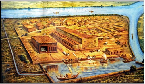
The Indus River holds significant cultural and linguistic importance as well. It finds mention in the ancient Hindu scriptures, the Rigveda, referred to as "Sindhu." The name "India" is believed to have been derived from the river's name, as the Persian word "Hindu" and the Sanskrit word "Sindhu" share a common origin. The ancient Greeks referred to the Persians as "Indos" and the inhabitants of the region as "Indoi," signifying "The People of the Indus." This linguistic connection further underscores the historical and cultural significance of the Indus River in shaping the identity of the land it flows through.
Geographical Features
The Indus River begins its course in the southwestern Tibet Autonomous Region of China, near Lake Mapam. It starts at a high elevation of around 18,000 feet (5,500 meters) and initially flows northwest. Along its path, it crosses the southeastern boundary of the disputed Kashmir region and receives its first major tributary, the Zanskar River, near Leh in Ladakh, India.
Continuing into the Pakistani-administered areas of Kashmir, the Indus is joined by another significant tributary, the Shyok River. As it moves downstream, it is fed by powerful glaciers from the Karakoram Range, Nanga Parbat massif, and Kohistan highlands. The Shigar, Gilgit, and other streams also contribute their glacial meltwater to the Indus.
Leaving this mountainous region, the Indus transforms into a fast mountain stream, passing between the Swat River and Hazara areas in Khyber Pakhtunkhwa province. It continues its course until it reaches the Tarbela Dam reservoir. Just above Attock, the Kabul River joins the Indus, and this is where the river flows at an elevation of 2,000 feet (600 meters), crossed by the first bridge accommodating rail and road.
Afterwards, the Indus crosses the Salt Range near Kalabagh, entering the Punjab Plain. It receives the waters of the Jhelum, Chenab, Ravi, Beas, and Sutlej rivers, collectively known as the Punjab ("Five Rivers").
At this point, the Indus grows significantly larger, particularly during the flood season, stretching several miles wide. It flows slowly across the plain, depositing silt on its bed, gradually raising it above the sandy plain. In fact, much of the plain in Sindh province in Pakistan owes its formation to the alluvium carried by the Indus.
Major tributaries of Indus River in India
The Indus River in India is fed by several major tributaries. These tributaries play a crucial role in contributing to the flow and water supply of the Indus River. Here are the major tributaries of the Indus River in India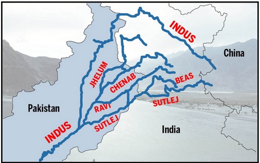
Chenab River:
Originating from the BaraLacha Pass in the Zaskar Range, the Chenab River is formed by the confluence of the Chandra and Bhaga rivers in Himachal Pradesh. It flows through Jammu and Kashmir before entering Pakistan's Punjab plains.
Sutlej River:
The Sutlej River starts from the southern slopes of Kailash Mountain, flows through Himachal Pradesh, and joins the Beas River in Punjab. It provides water for power generation and irrigation.
Beas River:
Originating from the Rohtang Pass, the Beas River joins the Sutlej River in Punjab. It is known for its scenic beauty and is a popular tourist destination in Himachal Pradesh.
Ravi River:
Starting from the Kullu Hills, the Ravi River flows through Himachal Pradesh and enters Pakistan through Amritsar. It joins the Chenab River in Pakistani Punjab.
Jhelum River:
The Jhelum River originates from Verinag in the Kashmir Valley, flows through Baramulla, and forms a border between India and Pakistan. It joins the Chenab River at Trimmu.
These major tributaries contribute to the water supply, hydrology, and overall ecosystem of the Indus River system, making them vital components of the larger river network.
To prevent flooding, embankments have been constructed, but occasional breaches can result in devastating floods. The Indus has witnessed significant flood events in the past, such as those in 1947, 1958, and 2010. During periods of heavy flooding, the river can change its course. Near Tatta, the Indus branches into distributaries that form a delta, stretching over an area of 3,000 square miles (7,800 square kilometers). This delta extends along the coast for approximately 130 miles (210 kilometers), with an uneven surface containing a network of existing and abandoned channels. The coastal strip, around 5 to 20 miles (8 to 32 kilometers) inland, is prone to flooding during high tides. The Indus delta boasts elongated protruding distributaries and low sandy beaches.
Climate
The climate in the Indus region varies significantly along its course. Here is a detailed description of the climate characteristics:
- Precipitation: The annual precipitation in the Indus region ranges from 5 to 20 inches (125 to 510 mm). The driest part of the subcontinent lies in the Indus valley, except for the mountainous section of Pakistan. Winter winds from the northwest bring vital rainfall of 4 to 8 inches (100 to 200 mm) to the upper Indus valley, supporting the cultivation of wheat and barley. The upper Indus region receives precipitation in the form of snow, which contributes to the river's water supply. The monsoon rains from July to September provide the remaining flow of the river.
- Regional Climate: The climate of the Indus valley varies across different regions. The Sindh and Punjab provinces experience a dry semi desert climate, while the high mountain regions such as Kohistan, Hunza, Gilgit, Ladakh, and western Tibet have a severe high mountain climate. In the mountainous north, January temperatures average below freezing, while in Sindh and Punjab provinces, July daytime high temperatures average around 100 °F (38 °C). Jacobabad, located in northern Sindh, is known as one of the hottest spots on Earth, with summer maximum temperatures often reaching 120 °F (49 °C).
- Snowmelt and Glaciers: The Indus river receives a significant portion of its water from the melting of snow and glaciers in the Karakoram, Hindu Kush, and Himalayan ranges. These mountainous regions contribute to the river's flow by providing water from the melting snow and ice, which is crucial for irrigation and sustaining river ecosystems.
The diverse climate along the Indus river basin influences agricultural practices, water availability, and the overall ecology of the region. It presents both challenges and opportunities for the people living in these areas, and understanding the climatic patterns is important for sustainable development and resource management.
Ecological Importance
- Biodiversity Hotspot: The Indus Basin is considered a biodiversity hotspot due to its diverse range of ecosystems and the presence of numerous plant and animal species. It encompasses various habitats, including forests, wetlands, grasslands, and riverine systems. These habitats support a rich array of flora and fauna, including several endemic and endangered species. The basin is home to iconic wildlife such as the Indus river dolphin, snow leopard, Himalayan brown bear, and several bird species.
- Habitat for Wildlife: The Indus Basin provides crucial habitats for a wide variety of wildlife. It serves as a breeding ground, feeding area, and migration route for numerous species. Migratory birds from different parts of the world visit the wetlands of the Indus Delta, while various fish species rely on the river for their life cycle. The diverse habitats within the basin support a complex web of ecological interactions and contribute to the overall health and resilience of the ecosystem.
- Water Source: The Indus River is a vital water source for the region. It provides water for irrigation, drinking, and industrial purposes, supporting agriculture and sustaining livelihoods. The river's flow also facilitates hydropower generation, contributing to the region's energy needs. The sustainable management of water resources in the basin is crucial for both human well-being and the health of the ecosystem.
- Wetland Conservation: The Indus Basin includes important wetland areas, such as the Indus Delta and several Ramsar sites. Wetlands play a critical role in flood control, water purification, and as a habitat for unique plant and animal species. They act as natural filters, trapping sediments and pollutants, and providing breeding grounds for fish and other aquatic organisms. Preserving and restoring these wetlands is essential for maintaining the ecological balance and supporting the livelihoods of local communities.
- Natural Resource Management: The Indus Basin contributes significantly to natural resource management. The forests within the basin act as carbon sinks, sequestering carbon dioxide and mitigating climate change. They also provide timber, fuelwood, and other non-timber forest products. The region is rich in mineral resources such as coal, gypsum, and limestone, which play a role in the local economy. Sustainable management practices are necessary to ensure the conservation and responsible use of these resources.
- Climate Regulation: The vegetation cover in the Indus Basin plays a crucial role in regulating the regional climate. Forests help in moisture retention, reducing soil erosion, and mitigating the impacts of floods and droughts. The vegetation also contributes to cooling the local climate and reducing the heat island effect in urban areas. Protecting and restoring forests and other vegetation cover is essential for climate regulation and maintaining the ecological balance within the basin.
- Carbon Sink: Forests and vegetation in the Indus Basin act as carbon sinks, absorbing carbon dioxide from the atmosphere and storing it in biomass and soils. This helps mitigate climate change by reducing greenhouse gas emissions. Protecting and expanding forest cover within the basin can contribute to carbon sequestration and help in climate change mitigation efforts.
Preserving the ecological integrity of the Indus Basin is crucial for maintaining biodiversity, supporting sustainable development, and ensuring the well-being of both human and natural communities in the region. It requires a holistic approach that integrates conservation, sustainable resource management, and the involvement of local communities in decision-making processes.
Hydrology of Indus Basin
The hydrology of the Indus River, which flows through the Himalayas, is influenced by various factors and exhibits seasonal variations.
The Indus River system primarily consists of snow-fed rivers. Their water flow varies throughout the year. During winter (December to February), the discharge is at its lowest. In spring and early summer (March to June), there is a rise in water levels. The rainy season (July to September) brings floods, sometimes resulting in devastating flash floods. The upper parts of the catchments, located in hilly areas, contribute the most water to the Indus and its tributaries. When these rivers emerge from the foothills, they have their highest flow. However, as they reach the plains, evaporation and seepage reduce the volume of water. After the monsoon season, some water is added through seepage. The water level of the Indus is lowest from mid-December to mid-February, starts rising from March, reaches its peak between mid-July and mid-August, and then gradually subsides until October. The upper Indus carries about half of the total water supply in the Indus River system, while the Jhelum and Chenab carry one-fourth, and the Ravi, Beas, and Sutlej contribute the rest.
Over time, there has been evidence of the Indus River shifting its course since ancient times, especially in its delta region. From southern Punjab province to the sea, the river has experienced changes in its path. While it is currently constrained by limestone ridges in Sindh, it has historically shifted westward, including in the last seven centuries. The Indus River's course is influenced by various factors, and the potential for future shifts cannot be disregarded. Similarly, other rivers like Chenab, Ravi, Beas, and Sutlej have also exhibited evidence of changing courses during the historical period.
The dynamic nature of the Indus River and its tributaries underscores the need for careful monitoring and management to mitigate the risks associated with changing water levels and potential shifts in the river's path.
Economic Importance
Irrigation from the Indus River has played a crucial role in supporting agriculture for centuries. The development of modern irrigation systems began in the mid-19th century, during British administration, with the revival and modernization of existing canals in the Sindh and Punjab regions. This led to the creation of the world's largest canal irrigation system.
However, at the partition of British India in 1947, the irrigation system was divided between India and West Pakistan (now Pakistan), causing disruptions in water supply for some parts of Pakistan. To resolve this, the Indus Waters Treaty was established in 1960, assigning the flow of the Indus, Jhelum, and Chenab rivers to Pakistan, and the flow of the Ravi, Beas, and Sutlej rivers exclusively to India.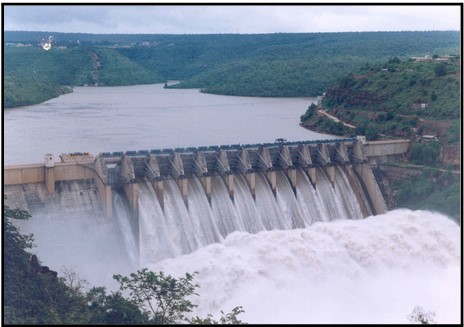
Both India and Pakistan have constructed dams, barrages, and link canals to distribute water for irrigation. In India, the Harike Barrage diverts water from the Beas and Sutlej rivers to the Indira Gandhi Canal, providing irrigation to desert areas in Rajasthan. In Pakistan, several linking canals and barrages have been built, such as the Chashma-Jhelum link canal, to transfer water from western rivers to areas lacking water in the east.
Major dams in Pakistan include the Mangla Dam on the Jhelum River, which generates hydroelectricity and provides water for irrigation and tourism, and the Tarbela Dam on the Indus River, with a greater generating capacity and potential. The Ghazi Barotha hydroelectric project and several barrages, such as the Guddu, Sukkur, and Kotri Barrages, further contribute to irrigation and electricity generation.
While canal irrigation has significantly supported agriculture, it has also posed challenges. Poorly controlled canals can lead to waterlogging and salinization of land. Efforts have been made to address these issues by providing drainage systems to prevent waterlogging and salt buildup.
Overall, irrigation from the Indus River has been vital for sustaining agricultural productivity, fostering economic development, and meeting the water needs of both India and Pakistan.
Socio-cultural Significance
The Indus River holds significant socio-cultural importance in the regions it traverses. Here are some key aspects:
- Historical and Cultural Significance: The Indus River has been home to ancient civilizations, including the Indus Valley Civilization (also known as the Harappan Civilization), one of the world's oldest urban civilizations. The remnants of this civilization provide valuable insights into early human settlements and urban planning. The river's presence shaped the cultural development of the region and influenced art, architecture, trade, and social structures.
- Economic Livelihood: The river has been a lifeline for communities residing along its banks. It supports diverse economic activities such as agriculture, fishing, and transportation. The fertile plains of the Indus basin provide ideal conditions for farming, with crops like wheat, cotton, rice, and sugarcane being cultivated. The river also sustains a variety of fish species, supporting fishing communities and providing a source of livelihood.
- Religious and Spiritual Significance: The Indus River holds religious and spiritual importance in the beliefs and practices of various communities. It is considered sacred by Hinduism, with pilgrims visiting its banks for religious rituals and immersion of ashes. The river is also mentioned in ancient scriptures, such as the Rigveda, and holds symbolic value in regional folklore and traditions.
- Cultural Diversity and Heritage: The Indus River basin is home to diverse communities, each with its distinct cultural practices, languages, and traditions. The river has served as a meeting point for different cultures, fostering exchanges, trade, and intercultural interactions. Festivals, rituals, and folklore associated with the river reflect the rich cultural heritage of the region.
- Tourism and Recreation: The scenic beauty of the Indus River, coupled with its historical and cultural significance, attracts tourists and nature enthusiasts. People engage in activities like river cruises, rafting, and exploration of archaeological sites and ancient settlements along the riverbanks. Tourism contributes to local economies and promotes cultural exchange.
- Water Resource Management: The Indus River plays a critical role in water resource management, providing water for domestic, agricultural, and industrial purposes. The river and its tributaries are managed through infrastructure projects like dams, barrages, and canal systems, ensuring equitable distribution of water resources among different regions and communities.
Overall, the Indus River holds immense socio-cultural value, shaping the lives, economies, and cultural heritage of the people living along its course. It is not just a physical entity but a living symbol of shared history, traditions, and aspirations of the diverse communities it nurtures.
Challenges and Conservation Efforts
The Indus River faces several modern issues that have significant social, environmental, and economic implications. Here are some key challenges:
- 1. Indus Delta Degradation: Construction of dams, barrages, and irrigation systems has significantly reduced the flow of water reaching the Indus delta. This reduced freshwater inflow, combined with deforestation, industrial pollution, and global warming, poses a threat to the delta's vegetation and wildlife. The population of the Indus river dolphin has been isolated due to damming, impacting its survival. The degradation of the delta affects local communities dependent on its resources.
Climate Change Impacts: The melting of glaciers in the Tibetan Plateau, which serve as a crucial water source for the Indus River, is occurring at an alarming rate. While this initially increases water availability, it raises concerns about the long-term implications. The retreating glaciers and altered water supply patterns due to climate change could have severe consequences for water availability, agriculture, and ecosystems in the Indus basin.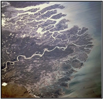
- Water Scarcity and Management: The Indus River Basin faces increasing water scarcity and management challenges. Population growth, industrial development, and agricultural demands strain the available water resources. Inefficient water management practices, including inadequate maintenance of canals and irrigation systems, contribute to water loss and reduced agricultural productivity. Balancing water allocation among different sectors and ensuring sustainable water use is a critical issue.
- Pollution: Industrial activities along the Indus River have led to high levels of water pollution, affecting both aquatic life and human health. The discharge of untreated industrial waste and agricultural runoff containing fertilizers and pesticides contaminates the river. Pollution has led to the decline of endangered species like the Indus river dolphin and poses risks to communities reliant on the river for drinking water and agriculture.
- Plastic Waste: The Indus River is among the top contributors of plastic waste to the world's oceans. Improper waste management and the lack of effective recycling infrastructure result in large amounts of plastic debris entering the river. This not only harms aquatic life but also has broader environmental implications, including ecosystem disruption and microplastic contamination.
Addressing these challenges requires comprehensive measures such as improving water management practices, implementing effective pollution control measures, promoting sustainable agriculture, and raising awareness about the importance of environmental conservation. Collaborative efforts involving governments, local communities, and international organizations are necessary to safeguard the Indus River's ecological integrity and ensure its sustainable use for present and future generations.
Indus Water Treaty
The Indus Water Treaty, signed in 1960, is an important agreement between India and Pakistan that governs the sharing of water resources from the Indus River and its tributaries. It was brokered by the World Bank and is considered one of the most successful water-sharing treaties in the world.
The treaty was necessary because the Indus River flows through both India and Pakistan, and tensions over water sharing had been rising between the two countries. The agreement aimed to provide a framework for managing water distribution fairly and peacefully.
Under the treaty, the Indus River and its three western tributaries, namely the Jhelum, Chenab, and Indus itself, were assigned to Pakistan. India was given control over the three eastern tributaries, namely the Ravi, Beas, and Sutlej. This division was based on the principle of equitable sharing, ensuring that both countries had access to water resources.
The treaty established a Permanent Indus Commission composed of representatives from both India and Pakistan to resolve any disputes or issues related to the implementation of the treaty. The commission meets regularly to exchange data, discuss water projects, and address concerns.
One of the key provisions of the treaty is the permission for each country to construct storage facilities, such as dams and barrages, on their allocated rivers. However, certain restrictions were placed to prevent significant harm to the other country. For instance, India agreed to limit the storage capacity of its projects on the western rivers to avoid reducing the water flow to Pakistan.
The treaty also promotes cooperation between the two countries in sharing data and information about river flows, hydrological data, and planned water projects. This transparency helps build trust and allows both sides to make informed decisions about water management.
The Indus Water Treaty has played a crucial role in preventing major conflicts over water resources between India and Pakistan. It has endured through periods of political tensions and conflicts between the two nations. The treaty has provided a mechanism for resolving disputes and has facilitated the development of water infrastructure and irrigation systems in both countries.
However, challenges and disputes still arise, particularly regarding the construction of new dams or water projects by either country. The treaty requires constant dialogue and cooperation to address emerging issues and ensure the equitable sharing of water resources.The Indus Waters Treaty has been marred by issues and accusations of violations from both India and Pakistan. Pakistan raised concerns about India's hydroelectric projects, while India objected to Pakistan's projects in the Rann of Kutch. Bilateral relations have deteriorated, leading India to take steps to divert water from Pakistan. These include reviewing the Tulbul project suspension, objecting to the LBOD project, and initiating projects to utilize its share of water. There are also debates about the treaty's signing by Prime Minister Nehru instead of the head of state.
Overall, the Indus Water Treaty is a significant milestone in international water diplomacy. It has contributed to regional stability and cooperation by managing water resources in a fair and mutually beneficial manner. The treaty serves as a model for other countries facing similar challenges, highlighting the importance of dialogue, cooperation, and equitable sharing for sustainable water management.
Conclusion
In conclusion, the Indus River system holds immense significance in South Asia, serving as a symbol of interconnectedness between nature, history, culture, and development. From its role in ancient civilizations to its economic importance in irrigation, hydropower, and transportation, the river has shaped the region's identity and livelihoods. However, the Indus River faces modern challenges such as climate change, pollution, and water scarcity, which threaten its sustainability. To ensure its preservation, collaborative efforts and conservation initiatives are essential. By recognizing the importance of the Indus River and taking collective action, we can safeguard this majestic and vital resource for the present and future generations.